Explained: China releases distorted 'standard' map. What exactly is the controversy?
https://www.wionews.com/world/expla...rd-map-what-exactly-is-the-controversy-630264
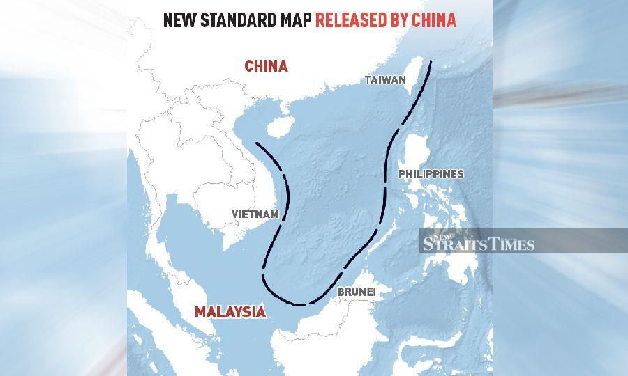
Antagonising almost its entire neighbourhood, China on Monday (August 29) released its official 'standard map' wherein it showed the Indian northeastern state of Arunachal Pradesh and the Aksai Chin region as part of its territory. Taiwan and the disputed South China Sea have also been included within the Chinese territory in the new map.
The Chinese government's mouthpiece Global Times took to X, formerly known as Twitter, to share the 'distorted' map, claiming it has been "compiled based on the drawing method of the national boundaries of China and various countries in the world".
"The 2023 edition of China's standard map was officially released on Monday and launched on the website of the standard map service hosted by the Ministry of Natural Resources," read the post.
(Disclaimer: This is an inaccurate map as it violates internationally accepted borders)
The 2023 edition of China's standard map was officially released on Monday and launched on the website of the standard map service hosted by the Ministry of Natural Resources. This map is compiled based on the drawing method of national boundaries of China and various countries…
pic.twitter.com/bmtriz2Yqe
— Global Times (@globaltimesnews)
August 28, 2023
×
The map shows Arunachal Pradesh, which China claims is part of Tibet, more specifically South Tibet and Aksai China occupied by it in the 1962 war. Additionally, Taiwan has been incorporated as part of Chinese territory.
Arunachal Pradesh and Aksai Chin
Last month, China and India were at loggerheads yet again after Beijing issued stapled, not stamped, visas to Indian athletes hailing from Arunachal Pradesh, who were to participate in the wushu (martial art) championship in the mainland.
The athletes applied for a Chinese visa on July 16. The applications of all athletes were processed in time and stamped visas were issued subsequently barring applications from three Arunachal athletes -- Nyeman Wangsu, Onilu Tega and Mepung Lamgu. They were first asked to resubmit their applications and later were issued stapled visas.
Also read | 'Unacceptable': India slams China over stapled visas issued to three Wushu fighters from Arunachal
Beijing considers AP a part of its sovereign borders and calls the state as “Zangnan, the southern part of Tibet". It disputes the legality of the McMahon Line which was agreed upon at the Simla Convention of 1914 between Tibet and British India.
Meanwhile, the dispute of Aksai Chin can be traced back to the British imperialists, who failed to clearly demarcate the border between India and China. Currently, the Line of Actual Control (LAC), where the two countries have been locked in a tussle for over two years now, separates Indian areas of Jammu & Kashmir from Aksai Chin.
New Delhi, however, has outrightly rejected the map, with External Affairs Minister S Jaishnkar pointing out that it wasn't the first time China had come out with a similar move.
"It's an old habit of theirs. These (territories) are very much part of India. This government is very clear what our territories are. Making absurd claims doesn't make others territories yours," the minister was quoted as saying by NDTV.
Taiwan
China painting Taiwan with its communist colours on the map has not come as a surprise to most geopolitical hawks. The Xi Jinping regime has been extremely protective of its 'One China policy' under which it claims Taiwan as an indelible sovereign part of its territory. However, over the last 12 months, Taipei has continuously pounded Beijing's ego by batting for its independence.
In August last year, former US House speaker Nancy Pelosi visited the island nation much to the chagrin of Beijing. As a retaliatory move, the PLA Navy deployed troops and warships that routinely crossed the Taiwan Strait and practised manoeuvres that might be performed during a future invasion.
Also read | China's map claiming regions beyond its border, including India, shows Beijing's 'aggressive character'
Earlier this year, Taiwanese President Tsai-Ing Wen visited New York, forcing Beijing's top diplomat Wang Yi to release a statement where he said Taipei remained a sovereign part of China and that no compromise was possible on the issue.
However, days later, the US State Department approved the potential sale of ammunition and logistics support to Taiwan, valued at up to $440 million. The defence contract confirmation came in the backdrop of the two countries signing the first deal under a new trade talks framework in June 2023.
Nine-dash line
Having been embroiled in a battle of territorial domination with the Philippines over the course of the last few weeks in the South China Sea, it was only imperative that Beijing propounded its nine-dash line theory on the map.
The nine-dash line is a fictional Chinese claim in the South China Sea, nearly encompassing the entire 'economically powerful' region, including the disputed Spratly and Paracel islands. The likes of the Philippines. Vietnam, Malaysia and Japan have time and again called out the Dragon for its expansionist tendencies in the region.
South China Sea is the main maritime link between the Pacific and Indian oceans, giving it massive trade and military value. It has become a major flashpoint in the Indo-Pacific because of the territorial disputes. The shipping lanes connect East Asia with Europe and the Middle East, which is responsible for trillions of dollars in ship-borne trade passing through the sea annually.


