- Joined
- Jul 10, 2008
- Messages
- 64,816
- Points
- 113

Cyclone's tail packs a windy punch
By Patrice Dougan @PatriceDougan
4:32 PM Tuesday Jan 21, 2014

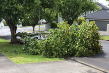
The winds brought this tree down on a car in Martin Avenue in the Auckland suburb of Remuera. Photo / Greg Taylor
Strong winds in Auckland have brought down trees, cut power to hundreds of homes and prompted a warning to drivers as ex-Cyclone June lashes the upper North Island.
MetService meteorologist Dan Corbett said Northland and Auckland were receiving the brunt of the storm this afternoon, with wind gusts of up to 100km/h at Manukau Heads.
Is it windy where you are? Having some weather issues? Send us your photos or videos here.
There were also strong gusts of up to 90km/h at Auckland airport and gusts of 100km/h in exposed parts of the Hauraki Gulf.
A Fire Service northern communications spokeswoman said there had been about nine callouts before the wind picked up in Auckland, and fewer than 10 since.
"Trees on roofs, on cars, on power lines, roofs coming off - that sort of thing. But it's dropped off a bit. We were steady for about half an hour, probably about 3pm.''
Among the jobs were a tree on a roof in Panmure, a tree on a house and power lines in Epsom, and a tree on a car. All had been dealt with quickly.
Lines company Vector said 1856 customers were without power due to four weather-related outages in the northern part of the network. In Titirangi, 880 customers were without power after a tree struck a line. There were 99 customers without power in Waiwera, 149 in Puhoi, 195 in Helensville and 533 in Muriwai.
Vector spokeswoman Sandy Hodge said crews were continuing to work in blustery conditions to restore further customers.
The New Zealand Transport Agency is urging motorcyclists and high-sided vehicles to take extra care on the Harbour and Mangere bridges due to strong winds.
Mr Corbett said the bad weather would linger around Auckland for the next couple of hours before moving over the Bay of Plenty.
<nzh-inline-video id="140330" position="center" media-id="13801420"></nzh-inline-video>
Mr Corbett said the low from the ex-cyclone was bringing strong southwesterly winds to Northland, Auckland and most recently the Bay of Plenty.
"We're just sitting around the peak, in the next hour or two, of this strong core of sou'westers moving across this part of the country. That will ease back, as it already has done so across the north of Northland.''
The strong winds would move to Tauranga and the eastern Bay of Plenty this evening as the low moved east of the North Island.
"The actual centre of the low currently sits probably somewhere about Rotorua, so you can imagine a clockwise flow of wind going around it. "The initial band of subtropical rain started off this morning in the shape of a boomerang from Taranaki to Wellington. That is easing and fragmenting and it's drifting back slowly across Cook Strait, coming back into Wellington.''
<nzh-inline-image id="12549569" position="center"></nzh-inline-image>
By tomorrow morning, the remains of the subtropical low would be sitting east of Hawkes Bay, leaving a typical westerly flow.
"There will be some patchy cloud, but it's a dry, brighter looking start to the day.''
By Patrice Dougan @PatriceDougan
- APNZ
Copyright ©2014, APN Holdings NZ Limited


 :oIo: you will be forgotten