- Joined
- Jul 14, 2008
- Messages
- 6,464
- Points
- 0
Remote Controlled Boeing 777, second smaller plane involved.
Boeing 777's can be "flown by wire", meaning that they can be remote controlled, taking over all controls from the pilots. It is possible that the pilots were incapacitated, the aircraft quickly brought up to 45,000 feet from its cruising altitude of 35,000 feet, thus rendering its occupants unconscious.
A white-hat "hacker" has revealed that even with the use of an Android app, given the right additional technical knowledge, a Boeing 777 can be taken over and flown remotely. However, this method of control would require clear data-over-radio communication with the aircraft which cannot be achieved over long distances far beyond line of sight of the operator and the aircraft.
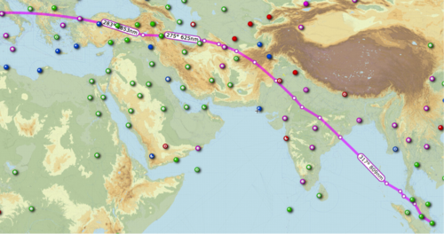
There is no evidence that the unidentified aircraft that was shown on Malaysia's military radar to have flown back from the last known location of MH370 in the opposite direction and across Malaysia roughly over the Thailand-Malaysian border, was MH370.
It is equally possible that an aircraft had been near MH370 over the South China Sea and took control of the Malaysian airliner via this mechanism, possibly with or without on-board assistance (we do not know if the abilities of the remote control flying, alleged to have also been involved in some of the 9/11 kamikaze flights, allows for transponders and other systems to be switched off).
Having taken control the "remote hijacker" in the other aircraft could have raised the flight level of MH370 to Flight Level 450 (45,000 feet) taking it 2,000 feet above its maximum allowed altitude, and also making it likely invisible to ground radar. It could then have flown at very low altitude close to sea and ground level, to avoid radar detection itself, while keeping the MH370 high above it.
This hypothesis is in fact backed up by much evidence on the ground in Malaysia on both sides of the peninsula near the Thai-Malay border: many independent and honest reports were given to local authorities by eye witnesses of aircraft noises and sightings at low level at the time the flight would have passed by. However, these would have been of the hijacking aircraft not the hijacked one.
Thus ensuring that MH370 continued on a flight path out into the southern Indian Ocean, at forty five thousand feet, killing all on board, until the aircraft ran out of fuel and fell into the sea: any traces would be hard to find and could take many years, given the remote area and depth of the sea, as well as its roughness.
Boeing 777's can be "flown by wire", meaning that they can be remote controlled, taking over all controls from the pilots. It is possible that the pilots were incapacitated, the aircraft quickly brought up to 45,000 feet from its cruising altitude of 35,000 feet, thus rendering its occupants unconscious.
A white-hat "hacker" has revealed that even with the use of an Android app, given the right additional technical knowledge, a Boeing 777 can be taken over and flown remotely. However, this method of control would require clear data-over-radio communication with the aircraft which cannot be achieved over long distances far beyond line of sight of the operator and the aircraft.
There is no evidence that the unidentified aircraft that was shown on Malaysia's military radar to have flown back from the last known location of MH370 in the opposite direction and across Malaysia roughly over the Thailand-Malaysian border, was MH370.
It is equally possible that an aircraft had been near MH370 over the South China Sea and took control of the Malaysian airliner via this mechanism, possibly with or without on-board assistance (we do not know if the abilities of the remote control flying, alleged to have also been involved in some of the 9/11 kamikaze flights, allows for transponders and other systems to be switched off).
Having taken control the "remote hijacker" in the other aircraft could have raised the flight level of MH370 to Flight Level 450 (45,000 feet) taking it 2,000 feet above its maximum allowed altitude, and also making it likely invisible to ground radar. It could then have flown at very low altitude close to sea and ground level, to avoid radar detection itself, while keeping the MH370 high above it.
This hypothesis is in fact backed up by much evidence on the ground in Malaysia on both sides of the peninsula near the Thai-Malay border: many independent and honest reports were given to local authorities by eye witnesses of aircraft noises and sightings at low level at the time the flight would have passed by. However, these would have been of the hijacking aircraft not the hijacked one.
Thus ensuring that MH370 continued on a flight path out into the southern Indian Ocean, at forty five thousand feet, killing all on board, until the aircraft ran out of fuel and fell into the sea: any traces would be hard to find and could take many years, given the remote area and depth of the sea, as well as its roughness.