- Joined
- Sep 22, 2008
- Messages
- 90,101
- Points
- 113
Around the same time, the "United Nations Convention on the Law of the Sea" came into force, and finally provided some serious motivation. It states that countries can extend their legal territories beyond their Exclusive Economic Zone, which reaches 200 nautical miles (370km) out from their coastlines, to claim their "extended continental shelf" – with all the mineral riches and oil this encompasses.
If New Zealand could prove that it was part of a larger continent, it could increase its territory by six times. Suddenly there was an abundance of funding for trips to survey the area, and the evidence gradually built up. With every rock sample that was collected, the case for Zealandia improved.
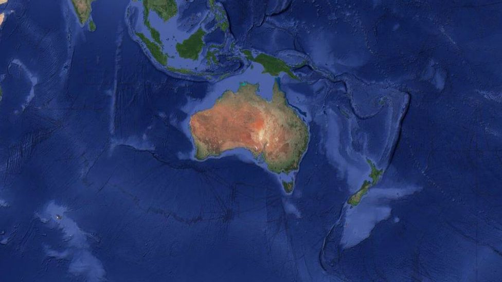
The final flourish came from satellite data, which can be used to track tiny variations in the Earth's gravity across different parts of the crust to map the seafloor. With this technology, Zealandia is clearly visible as a misshapen mass almost as large as Australia.

Satellite data can be used to visualise the continent of Zealandia, which appears as a pale blue upside-down triangle to the east of Australia (Credit: GNS Science)
When the continent was finally unveiled to the world, it unlocked one of the most sizeable maritime territories in the world. "It is kind of cool," says Mortimer, "If you think about it, every continent on the planet has different countries on it, [but] there are only three territories on Zealandia."
In addition to New Zealand, the continent encompasses the island of New Caledonia – a French colony famous for its dazzling lagoons – and the tiny Australian territories of Lord Howe Island and Ball's Pyramid. The latter was described by one 18th-Century explorer as appearing "not to be larger than a boat."
If New Zealand could prove that it was part of a larger continent, it could increase its territory by six times. Suddenly there was an abundance of funding for trips to survey the area, and the evidence gradually built up. With every rock sample that was collected, the case for Zealandia improved.
The final flourish came from satellite data, which can be used to track tiny variations in the Earth's gravity across different parts of the crust to map the seafloor. With this technology, Zealandia is clearly visible as a misshapen mass almost as large as Australia.

Satellite data can be used to visualise the continent of Zealandia, which appears as a pale blue upside-down triangle to the east of Australia (Credit: GNS Science)
When the continent was finally unveiled to the world, it unlocked one of the most sizeable maritime territories in the world. "It is kind of cool," says Mortimer, "If you think about it, every continent on the planet has different countries on it, [but] there are only three territories on Zealandia."
In addition to New Zealand, the continent encompasses the island of New Caledonia – a French colony famous for its dazzling lagoons – and the tiny Australian territories of Lord Howe Island and Ball's Pyramid. The latter was described by one 18th-Century explorer as appearing "not to be larger than a boat."
