http://ijamestann.blogspot.sg/2012/12/the-tragedy-at-sleepy-valley.html#comment-form
Tragedy at Sleepy Valley
In past articles, I have described some interesting places around Princess Elizabeth Estate.
I have also mentioned some places in the vicinity being famous as World War II heritage sites like Bukit Batok Hill and Ford Motor factory.
From historical records, we learned that Bukit Batok and Bukit Timah were the places where some of the fiercest battles were fought between the defending British forces against the invading Imperial Japanese Army.
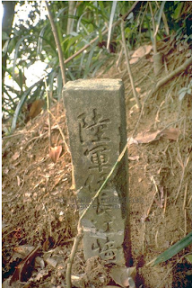
Though there is a general heritage marker at the top of Bukit Batok Hill and another at Bukit Timah Hill, most people today do not know exactly where these battlefields were. I will take you to one of the sites of a battle at Bukit Batok.
One of the most tragic events of the war in Singapore happened at a place called Sleepy Valley.
During a retreat from the enemy forces, a whole battalion comprising 1500 Australian, British and Indian soldiers was trapped and almost annihilated by the Imperial Japanese Army. Of the 1500 men, only 400 managed to escape to join their comrades further on defended locations.
A little background for the war enthusiast:
At 10.30 pm on 8th Feb 1942, the Japanese Army crossed the Straits of Johor and invaded Singapore through the Lim Chu Kang Sarimbun area. These areas were defended mainly by British soldiers from the Australian regiments.
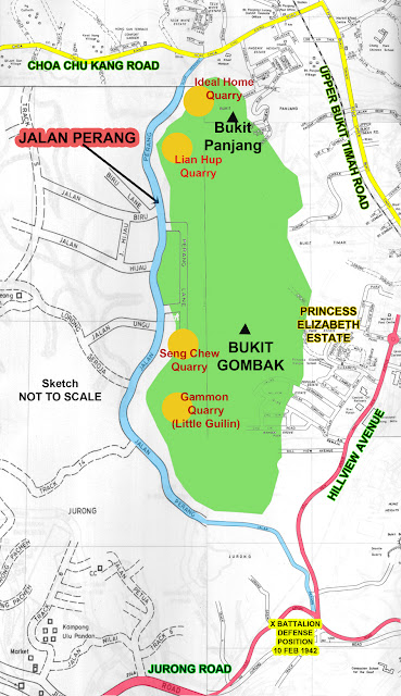
By 10th Feb, the British forces were pushed backed where they formed a defensive formation called the "Jurong Line". The Jurong Line covered the entire stretch from Kranji River in the north to the Jurong River in the south. Tactically, this blockade would contain the Japanese forces within the western sector of Singapore island.
However, the Jurong Line didn't hold, and by the afternoon, the British forces began retreating again.
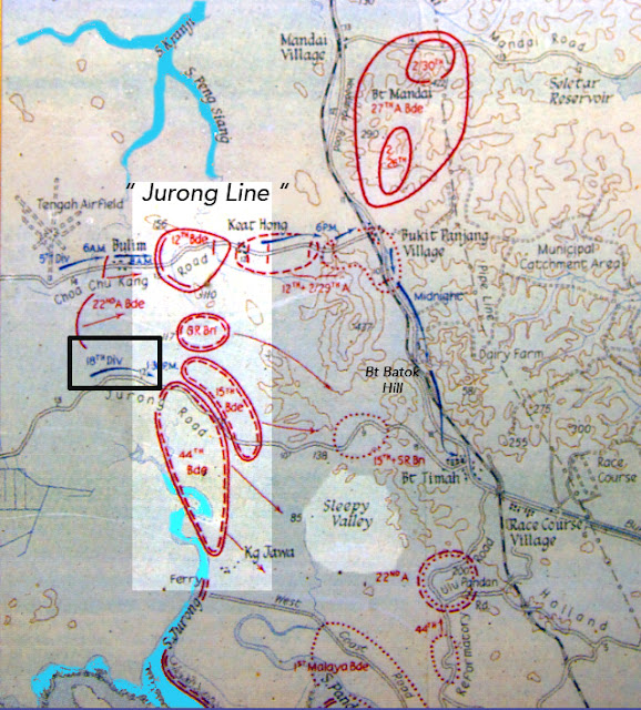
In the above war movement map, you can see the Australian forces spread out along the Jurong Line.
The 12th Brigade in the north retreated towards Bukit Panjang and defended its position there.
The 44th Brigade located south at the Jurong River, retreated towards Pasir Panjang and the City.
In the centre, 15th Brigade and the Special Reserve Battalion moved east towards Bukit Timah.
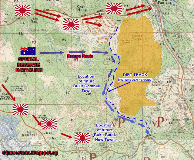
It is this last group of soldiers under the command of Brigadier Coates that re-grouped and fought the Japanese around Bukit Batok* area. By 7.30 pm, the commander realised that they were almost surrounded by the Japanese and ordered his troops to retreat south through Sleepy Valley towards the British lines at Ulu Pandan.
(* I use the term Bukit Batok as a reference to the area found today. In 1942 the entire area was still called "Jurong" [9th & 10th milestone]. Bukit Batok region was named by HDB/MND after the 1970s.)
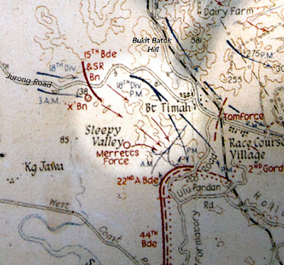
Unbeknownst to the retreating British forces, the Japanese Army 18th Division, whom they had been fighting, had already bypassed them along the ridge line that borders today's Jalan Jurong Kechil. (See the black arrow movements above)
The British forces regrouped, in an area where today the Bukit Batok Nature Park and St Mary of the Angels Church lies, and was ordered to move in columns through Sleepy Valley.
This escape route was unfortunately open farmlands with little cover and the Japanese Army had them trapped when they closed the pincer movement (the location where today's traffic turnoff from Toh Tuck Road to PIE lies).
The result was that 1100 men of the 1500 were killed at Sleepy Valley. By 10.30 pm, only 400 men managed to escaped from the Japanese towards the Australian defence line at Ulu Pandan.
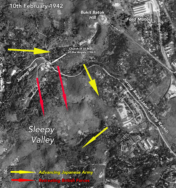
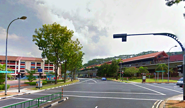
An aerial view of the region where the British forces were caught in the open
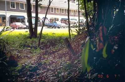
Today, this former battle site, Sleepy Valley, is long forgotten. Very few today have heard of it, much less know about its tragic history.
Bukit Batok East Avenue 3 runs through it with Yusof Ishak Secondary School and condominiums like Park View and Burgundy Hill occupying the site where the massacre of British forces took place.
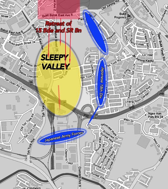
A graphic representation of the final movements of 15 Brigade and Special Reserve Battalion
superimposed on today's street map showing the location of the Sleepy Valley battle ground.
If you live in Bukit Batok or will pass through it, do remember this unmarked heritage site where once men fought and died for their country.
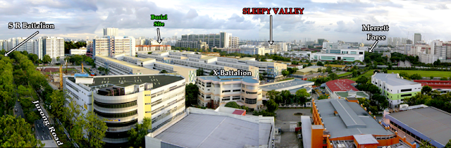
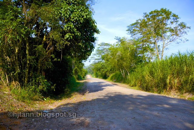
The Bukit Batok area today where the tragedy took place on 10th & 11th Feb 1942.
(Click on photo for enlarged view)
Posted by James Tann at Saturday, December 15, 2012
Tragedy at Sleepy Valley
In past articles, I have described some interesting places around Princess Elizabeth Estate.
I have also mentioned some places in the vicinity being famous as World War II heritage sites like Bukit Batok Hill and Ford Motor factory.
From historical records, we learned that Bukit Batok and Bukit Timah were the places where some of the fiercest battles were fought between the defending British forces against the invading Imperial Japanese Army.
Though there is a general heritage marker at the top of Bukit Batok Hill and another at Bukit Timah Hill, most people today do not know exactly where these battlefields were. I will take you to one of the sites of a battle at Bukit Batok.
One of the most tragic events of the war in Singapore happened at a place called Sleepy Valley.
During a retreat from the enemy forces, a whole battalion comprising 1500 Australian, British and Indian soldiers was trapped and almost annihilated by the Imperial Japanese Army. Of the 1500 men, only 400 managed to escape to join their comrades further on defended locations.
A little background for the war enthusiast:
At 10.30 pm on 8th Feb 1942, the Japanese Army crossed the Straits of Johor and invaded Singapore through the Lim Chu Kang Sarimbun area. These areas were defended mainly by British soldiers from the Australian regiments.
By 10th Feb, the British forces were pushed backed where they formed a defensive formation called the "Jurong Line". The Jurong Line covered the entire stretch from Kranji River in the north to the Jurong River in the south. Tactically, this blockade would contain the Japanese forces within the western sector of Singapore island.
However, the Jurong Line didn't hold, and by the afternoon, the British forces began retreating again.
In the above war movement map, you can see the Australian forces spread out along the Jurong Line.
The 12th Brigade in the north retreated towards Bukit Panjang and defended its position there.
The 44th Brigade located south at the Jurong River, retreated towards Pasir Panjang and the City.
In the centre, 15th Brigade and the Special Reserve Battalion moved east towards Bukit Timah.
It is this last group of soldiers under the command of Brigadier Coates that re-grouped and fought the Japanese around Bukit Batok* area. By 7.30 pm, the commander realised that they were almost surrounded by the Japanese and ordered his troops to retreat south through Sleepy Valley towards the British lines at Ulu Pandan.
(* I use the term Bukit Batok as a reference to the area found today. In 1942 the entire area was still called "Jurong" [9th & 10th milestone]. Bukit Batok region was named by HDB/MND after the 1970s.)
Unbeknownst to the retreating British forces, the Japanese Army 18th Division, whom they had been fighting, had already bypassed them along the ridge line that borders today's Jalan Jurong Kechil. (See the black arrow movements above)
The British forces regrouped, in an area where today the Bukit Batok Nature Park and St Mary of the Angels Church lies, and was ordered to move in columns through Sleepy Valley.
This escape route was unfortunately open farmlands with little cover and the Japanese Army had them trapped when they closed the pincer movement (the location where today's traffic turnoff from Toh Tuck Road to PIE lies).
The result was that 1100 men of the 1500 were killed at Sleepy Valley. By 10.30 pm, only 400 men managed to escaped from the Japanese towards the Australian defence line at Ulu Pandan.
An aerial view of the region where the British forces were caught in the open
Today, this former battle site, Sleepy Valley, is long forgotten. Very few today have heard of it, much less know about its tragic history.
Bukit Batok East Avenue 3 runs through it with Yusof Ishak Secondary School and condominiums like Park View and Burgundy Hill occupying the site where the massacre of British forces took place.
A graphic representation of the final movements of 15 Brigade and Special Reserve Battalion
superimposed on today's street map showing the location of the Sleepy Valley battle ground.
If you live in Bukit Batok or will pass through it, do remember this unmarked heritage site where once men fought and died for their country.
The Bukit Batok area today where the tragedy took place on 10th & 11th Feb 1942.
(Click on photo for enlarged view)
Posted by James Tann at Saturday, December 15, 2012
Last edited: