- Joined
- Aug 8, 2008
- Messages
- 6,070
- Points
- 83
https://en.wikipedia.org/wiki/Manipur
Manipur
From Wikipedia, the free encyclopedia
Jump to navigation Jump to search
For other uses, see Manipur (disambiguation).
Manipur State

Loktak Lake, around 30 km from the capital Imphal

Emblem
 Country

Lok Sabha 2 • High Court Manipur High CourtArea • Total 22,327 km2 (8,621 sq mi)Area rank 24thPopulation (2011[3]) • Total 2,855,794 • Rank 24th • Density 130/km2 (330/sq mi)Time zone UTC+05:30 (IST)ISO 3166 code IN-MNHDI

Manipur (/ˈmʌnɪpʊər/ (
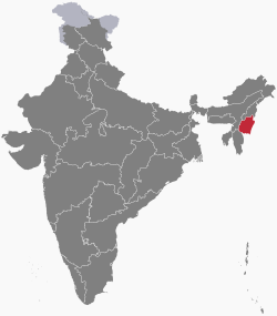
 listen)) is a state in Northeast India, with the city of Imphal as its capital.[6] It is bounded by Nagaland to the north, Mizoram to the south, and Assam to the west; Burma (Myanmar) lies to its east. The state covers an area of 22,327 square kilometres (8,621 sq mi) and has a population of almost 3 million, including the Meitei, who are the majority group in the state, Loi, Yaithibi, Kuki and Naga peoples, who speak a variety of Sino-Tibetan languages. Manipur has been at the crossroads of Asian economic and cultural exchange for more than 2,500 years.[7] It has long connected the Indian subcontinent to Southeast Asia and China, enabling migration of people, cultures and religions.[8][9]
During the Raj, the Kingdom of Manipur was one of the princely states.[10] Between 1917 and 1939, the people of Manipur pressed for their rights against British rule. By the late 1930s, the princely state of Manipur negotiated with the British administration its preference to be part of India, rather than Burma. These negotiations were cut short with the outbreak of World War II. On 11 August 1947, Maharaja Budhachandra signed the Instrument of Accession, joining India.[11][12] Later on 21 September 1949, he signed a Merger Agreement, merging the kingdom into India.[13] This merger has been disputed by groups in Manipur as having been completed without consensus and under duress.[14] The dispute and differing visions for the future has resulted in a 50-year insurgency in the state for independence from India, as well as in repeated episodes of violence among ethnic groups in the state.[15] From 2009 through 2018, the conflict was responsible for the violent deaths of over 1000 people.[16]
The Meitei ethnic group[17] represents 53% of the population of Manipur state. The main language of the state is Meitei (also known as Manipuri). Tribes constituting about 20% of the state population are distinguished by dialects and cultures that are often village-based. Manipur's ethnic groups practice a variety of religions.[18] According to 2011 census, Hinduism is the major religion in the state, closely followed by Christianity. Other religions include Islam, Sanamahism, Buddhism etc.[18][19]
Manipur has primarily an agrarian economy, with significant hydroelectric power generation potential. It is connected to other areas by daily flights through Imphal airport, the second largest in northeastern India.[20] Manipur is home to many sports and the origin of Manipuri dance,[21] andd is credited with introducing polo to Europeans.[22]
http://weitushe.com/xjmg/shot_spage_weitushe/get?tid=40237601
游记英国旅游
世界上第二个“中国”,国旗是六星红旗,外貌上跟中国人并没区别
2018-10-18 04:28
如今人们的生活越过越好,旅行也渐渐的走入人们的视线,成了人们生活中必不可少的一部分,旅行可以给人们带来欢乐,开阔我们的眼界,放松我们的心情。但是旅行也是一种学问,去哪里旅行,跟什么样的人一起去旅行,才让自己收获最大呢?古人说的好,读万卷书不如行万里路,这句话也是非常有道理的,这个世界上还有非常多我们所没有见识过的美丽风景,都在等待着我们去发掘。

世界上就有这么一个国家,它虽然名气不大,也不是旅游的热门地,可是每年却还是吸引着一部分的中国游客前来这里游玩。这个国家号称第二个“中国”,当地人讲的都是汉语,并且跟中国人一样是黄皮肤,黑头发,在外貌上跟中国人并没有太大区别。很多中国游客来到这里旅行,甚至还会有一种错觉,感觉自己还身在中国,因为这里实在是跟中国太像了。

这里就是曼尼普尔邦,他是印度东北的一个邦,虽然说是属于印度,可是却一直有独立的想法,因为在很久以前,曼尼普尔邦一直是一个独立的王国,并且也有2000年的历史。可是后来在英国占领印度之后,曼尼普尔邦也受到了同样的命运,遭到了英国侵略。可是曼尼普尔邦人却认为是印度人帮助英国人侵略他们,所以当地居民一直都跟印度军队时有冲突。

有人认为曼尼普尔邦其实是隋唐时期的汉人,是汉人来到这里建的国家,曼尼普尔人的血缘跟文化都跟中国有着太多相似之处了,他们在外貌上并没有跟中国有什么太大差异,并且他们的很多习俗也跟中国一样,例如我们国家一直对龙十分的崇拜,曼尼普尔人也一样,甚至他们还有赛龙舟,吃粽子等这种中国特有的习俗,所以来到这里完全没有出国的感觉。

曼尼普尔邦跟中国比较相似的地方,还有国旗跟国徽,我们国家的国旗是五星红旗,而他们国家的国旗只比我们多了一颗心,并且他们也是一颗大星星,围着几颗小星星。如果你没有认真看的话,还真会把他当成中国的国旗。曼尼普尔邦的国徽跟中国的国徽也非常的类似,但是我们国家的国徽是五个星星外加天安门广场,而他们的是六个星星,外加中间一条龙。
世界上第二个“中国”,国旗是六星红旗,外貌上跟中国人并没区别
2018-10-18 04:28

除了以上这些相似之处以外,曼尼普尔邦的当地人还非常喜欢中国,当地人还非常喜欢中国饮食,在这里你可以看到非常多的中国餐厅。并且中国功夫在这里也受到了当地居民的欢迎,很多年轻人都有去学中国功夫。曼尼普尔邦基本上限制的印度电影跟新闻,而他们最喜欢看的是中国大陆所拍的影视剧跟香港电影,曾经在曼尼普尔邦最火爆的一部电视剧,就是我们国家所拍的八六版《西游记》,甚至在当时火爆了整个曼尼普尔邦。对此,大伙怎么看呢?你觉得这个国家像不像是世界上的第二个中国呢?欢迎在留言区留言评论。

世界上第二个“中国”,国旗是六星红旗,外貌上跟中国人并没区别
