• IP addresses are NOT logged in this forum so there's no point asking. Please note that this forum is full of homophobes, racists, lunatics, schizophrenics & absolute nut jobs with a smattering of geniuses, Chinese chauvinists, Moderate Muslims and last but not least a couple of "know-it-alls" constantly sprouting their dubious wisdom. If you believe that content generated by unsavory characters might cause you offense PLEASE LEAVE NOW! Sammyboy Admin and Staff are not responsible for your hurt feelings should you choose to read any of the content here.

    The OTHER forum is HERE so please stop asking.

China invasion has started

syed putra

Alfrescian
Loyal
And PAP worried sbout a handful of terrorist carrying knives.
Malaysian navy vessels, Chinese ship reported in South China Sea standoff
FMT Reporters
-
November 26, 2020 1:13 PM
facebook sharing button

twitter sharing button

whatsapp sharing button

sharethis sharing button

navy-frigates-sub-marines-South-China-Sea-aircraft_ap.jpg
The Asia Maritime Transparency Institute reported that a Chinese ship had harassed a drilling rig and its supply ships last week. (AP pic)
PETALING JAYA: The China Coast Guard (CCG) and Royal Malaysian Navy (RMN) are reportedly involved in a standoff over hydrocarbon exploration 44 nautical miles off the coast of Sarawak in the South China Sea.
The incident comes after two weeks of increasing tensions between the navy and the CCG in the area.
According to a report by the Asia Maritime Transparency Institute (AMTI), the “CCG 5402” ship harassed a drilling rig and its supply ships on Nov 19, and the navy responded by deploying a vessel that continued to tail the ship.
Citing Automatic Identification System (AIS) data from marine traffic and satellite imagery from Planet Labs, the report said the CCG ship left Hainan on Oct 30 for what has become a standard Chinese patrol route.


Powered by Streamlyn


It first stopped at China’s island bases on Subi and Fiery Cross Reefs before taking up station at Luconia Shoals in Malaysia’s exclusive economic zone on Nov 2.
On Nov 10, the ship patrolled the oil and gas blocks west of Luconia Shoals, passing the Sapura Constructor, an offshore construction ship in the area.
RMN’s Bunga Mas Lima, a naval auxiliary ship that had left Sabah a day earlier, arrived at Luconia Shoals hours later and shadowed the ship for a few days. Its AIS broadcasts were spotty during this period, but satellite imaging from Nov 13 showed the ships just three nautical miles apart.
On Nov 12, the CCG ship headed 40 nautical miles east of Luconia Shoals for a quick patrol before returning to its post.

The report said the ship appeared to have been attracted by the arrival of a new jackup rig, Borr Drilling’s Gunnlod, which had been towed to its location in block SK410B just days earlier and is exploring for natural gas under a contract with Thailand’s PTT Exploration and Production (PTTEP).
The ship returned to the area on Nov 19 and came to within two nautical miles of the rig.
At just over 40 nautical miles from Sarawak, AMTI said this is the closest to shore they had ever documented such Chinese activity.
The Bunga Mas Lima continued patrolling the area and remained near Luconia Shoals for another two days.
Within hours, however, the RMN deployed a second ship, the more capable KD Keris, which steamed straight from Sabah to the Gunnlod. The Keris stayed near the rig for about a day before following the CCG ship back to Luconia Shoals.
The two ships manoeuvred around each other there for several days. When Ship 5402 went for another patrol to the west of Luconia Shoals on Tuesday, the Keris followed.
As of yesterday, the Gunnlod remained on site at block SK410B and the CCG ship has not returned.
AMTI said that recent history suggested that China could escalate the standoff with further deployments, but noted it might also deescalate in recognition that harassment of drilling operations so close to Malaysian shores is a significant provocation.
FMT has reached out to the defence ministry and foreign affairs ministry for comment.
 

Nice-Gook

Alfrescian
Loyal
Never trust chicom. Can suka suka drew 9 dash line and claimed its their backyard. Wahlou eh...

View attachment 97102
its a copy of Russian negotiation tactics

in any negotiation two parties will put forward their demands and mostly will reach a middle ground as settlement

realising this, Russians will take an extreme stand in tge hope even if they get 20% of their demand as final settlement ,they are still the nett gainers

fucking chincoms just copying this style by drawing line suka suka as their territories with wild histirical claims
 

whoami

Alfrescian (Inf)
Asset
Wahlou eh. Now chicom colonise Butan.

Satellite images appear to show China developing area along disputed border with India and Bhutan
By James Griffiths and Manveena Suri, CNN

Updated 0249 GMT (1049 HKT) November 25, 2020

1606615899441.png

An annotated satellite image of the China-Bhutan border in the disputed region of Doklam which appears to show a newly constructed village and supply depot.

Hong Kong (CNN)New satellite images appear to show China has built up an area in the Himalayas along a disputed border with India and Bhutan that was the site of a months-long standoff in 2017.
According to US-based satellite operator Maxar Technologies, the images, dated October 28, 2020, show "there has clearly been significant construction activity this year all along the Torsa River valley area." In a statement, Maxar added there had also been construction of "new military storage bunkers" near the Doklam area.
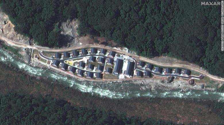
Maxar said the images show the newly constructed Pangda Village, on the Bhutanese side of the disputed border, as well as a supply depot in Chinese territory, near the point of a tense dispute between Indian and Chinese forces in 2017.
In a statement, Bhutan's ambassador to India, Major General Vetsop Namgyel, said "there is no Chinese village inside Bhutan."
China's Ministry of Foreign Affairs said that "China's normal construction activities on its own territory are entirely within the scope of China's sovereignty, and there is nothing wrong with it." India's Ministry of External Affairs did not respond to a request for comment.
Indian broadcaster NDTV first reported the satellite images.
Satellite imagery of the Chinese village of Pangda, provided by Maxar Technologies. The firm claims the village was built on the Bhutanese side of a disputed border with China.


Satellite imagery of the Chinese village of Pangda, provided by Maxar Technologies. The firm claims the village was built on the Bhutanese side of a disputed border with China.
A thin strip of land bordering all three countries, the Doklam area is claimed by both China and Bhutan, but it is also strategically important to India, because of its proximity to the Siliguri Corridor, a vital artery between New Delhi and its north eastern states.
"The Siliguri Corridor is strategically important and highly sensitive territory, as it remains the only bridge between the eight north-eastern states of India and the rest of the country," analyst Syed Fazl-e-Haider wrote earlier this year in an article published by Australian think tank, The Lowy Institute . "By an advance of just 130 kilometers (80 miles), the Chinese military could cut off Bhutan, west Bengal and the north-eastern states of India. About 50 million people in north-east India would be separated from the country."
In an article in the state-run Global Times newspaper Monday, Chinese experts were quoted refuting Maxar's claims and reports in Indian media that a village had been built in Bhutanese territory.
Just where the two countries draw their borders is highly disputed, however. The 2017 stand-off was sparked after Bhutan accused China of constructing a road inside its territory in "direct violation" of treaty obligations. China, which does not have formal diplomatic relations with Bhutan, denied the accusation, contending that the area is part of Chinese territory.
Bhutan is traditionally a strong ally of India's, relying on Delhi to provide training for its armed forces and cooperating closely with India on foreign policy. That appears to be shifting, however, particularly as the rivalry between Beijing and Delhi heats up.
Earlier this year, India and China engaged in a bloody clash along another disputed border in the Himalayas which left at least 20 soldiers dead, the worst conflict between the two countries since they fought a war over the same territory in 1962.
While both countries agreed to deescalate, Maxar Technologies' satellite imagery has shown that China continues to reinforce its position along the border with India, though further construction is unlikely at this time of year due to the harsh winter conditions high in the Himalayas.
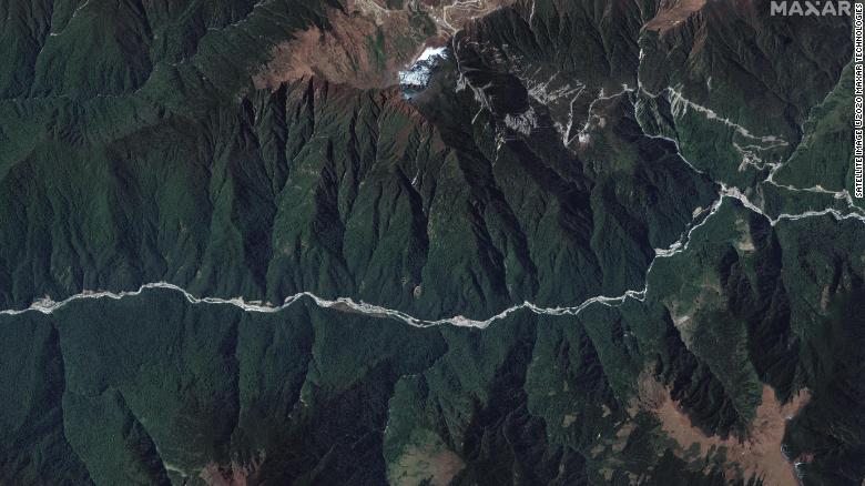
A wide view of the disputed Doklam area provided by Maxar Technologies.


A wide view of the disputed Doklam area provided by Maxar Technologies.
The continued gradual reinforcement of positions, and angrily rebuffed allegations of encroachment, has echoes of Beijing's behavior in the South China Sea, where it has built up and militarized islets, reefs and islands, giving it effective control of huge swaths of the disputed region, a hugely important fishing and shipping area over which sovereignty is claimed in part or whole by six other governments.


"They're asserting their claim so they're creating the facts on the ground so there's the village, which is part of a larger policy," said Manoj Joshi, a distinguished fellow at the Observer Research Foundation, a New Delhi-based think tank. "After (2017), they realized, just like the Indian side, their border areas are very thinly populated so it becomes very difficult to patrol the area. Now, by creating these facts on the ground, by creating this village, you can say it was always there. In the style of the Chinese, you create the facts on ground and then you say it's always been the case."
"I think (Bhutan has) figured that we'll live with it and not make a noise and just look the other way," Joshi said, adding that without its neighbor complaining, there is little Delhi can do.
"As the crow flies, this point is over 11 kilometers from the Indian position so there's nothing India can do unless Bhutan makes a public call for help. If you look at the Indo-Bhutanese Treaty, there's no explicit defense clause. So, essentially the Bhutanese live with it, we look the other way and the Chinese create the facts on the ground."
In particular, the rather tenuous nature of Pangda Village is reminiscent of the initial bases built on sandbars and tiny islets in the disputed waters. The high Himalayas are a hostile environment at the best of times, but as Nathan Ruser, an analyst at the Australian Strategic Policy Institute, the new village appears built more for territorial bragging rights than longevity.
"The high resolution imagery also shows how precarious of a village it is, being constructed on what is essentially a sandbank in the middle of a mountain river valley (where snowmelt and high cliffs make water flow unpredictable and flash floods common)," Ruser wrote on Twitter in response to the new imagery. "To combat this Chinese engineers have constructed a small retaining wall, I assume designed to keep any flood water out of the village. I'm not sure I'd trust it when the only way in and out is a road that would get flooded before the village."
 

ilovechinesegal

Alfrescian
Loyal
Wahlou eh. Now chicom colonise Butan.

Satellite images appear to show China developing area along disputed border with India and Bhutan
By James Griffiths and Manveena Suri, CNN

Updated 0249 GMT (1049 HKT) November 25, 2020

View attachment 97304
An annotated satellite image of the China-Bhutan border in the disputed region of Doklam which appears to show a newly constructed village and supply depot.

Hong Kong (CNN)New satellite images appear to show China has built up an area in the Himalayas along a disputed border with India and Bhutan that was the site of a months-long standoff in 2017.
According to US-based satellite operator Maxar Technologies, the images, dated October 28, 2020, show "there has clearly been significant construction activity this year all along the Torsa River valley area." In a statement, Maxar added there had also been construction of "new military storage bunkers" near the Doklam area.
Maxar said the images show the newly constructed Pangda Village, on the Bhutanese side of the disputed border, as well as a supply depot in Chinese territory, near the point of a tense dispute between Indian and Chinese forces in 2017.
In a statement, Bhutan's ambassador to India, Major General Vetsop Namgyel, said "there is no Chinese village inside Bhutan."
China's Ministry of Foreign Affairs said that "China's normal construction activities on its own territory are entirely within the scope of China's sovereignty, and there is nothing wrong with it." India's Ministry of External Affairs did not respond to a request for comment.
Indian broadcaster NDTV first reported the satellite images.
Satellite imagery of the Chinese village of Pangda, provided by Maxar Technologies. The firm claims the village was built on the Bhutanese side of a disputed border with China.


Satellite imagery of the Chinese village of Pangda, provided by Maxar Technologies. The firm claims the village was built on the Bhutanese side of a disputed border with China.
A thin strip of land bordering all three countries, the Doklam area is claimed by both China and Bhutan, but it is also strategically important to India, because of its proximity to the Siliguri Corridor, a vital artery between New Delhi and its north eastern states.
"The Siliguri Corridor is strategically important and highly sensitive territory, as it remains the only bridge between the eight north-eastern states of India and the rest of the country," analyst Syed Fazl-e-Haider wrote earlier this year in an article published by Australian think tank, The Lowy Institute . "By an advance of just 130 kilometers (80 miles), the Chinese military could cut off Bhutan, west Bengal and the north-eastern states of India. About 50 million people in north-east India would be separated from the country."
In an article in the state-run Global Times newspaper Monday, Chinese experts were quoted refuting Maxar's claims and reports in Indian media that a village had been built in Bhutanese territory.
Just where the two countries draw their borders is highly disputed, however. The 2017 stand-off was sparked after Bhutan accused China of constructing a road inside its territory in "direct violation" of treaty obligations. China, which does not have formal diplomatic relations with Bhutan, denied the accusation, contending that the area is part of Chinese territory.
Bhutan is traditionally a strong ally of India's, relying on Delhi to provide training for its armed forces and cooperating closely with India on foreign policy. That appears to be shifting, however, particularly as the rivalry between Beijing and Delhi heats up.
Earlier this year, India and China engaged in a bloody clash along another disputed border in the Himalayas which left at least 20 soldiers dead, the worst conflict between the two countries since they fought a war over the same territory in 1962.
While both countries agreed to deescalate, Maxar Technologies' satellite imagery has shown that China continues to reinforce its position along the border with India, though further construction is unlikely at this time of year due to the harsh winter conditions high in the Himalayas.
A wide view of the disputed Doklam area provided by Maxar Technologies.


A wide view of the disputed Doklam area provided by Maxar Technologies.
The continued gradual reinforcement of positions, and angrily rebuffed allegations of encroachment, has echoes of Beijing's behavior in the South China Sea, where it has built up and militarized islets, reefs and islands, giving it effective control of huge swaths of the disputed region, a hugely important fishing and shipping area over which sovereignty is claimed in part or whole by six other governments.


"They're asserting their claim so they're creating the facts on the ground so there's the village, which is part of a larger policy," said Manoj Joshi, a distinguished fellow at the Observer Research Foundation, a New Delhi-based think tank. "After (2017), they realized, just like the Indian side, their border areas are very thinly populated so it becomes very difficult to patrol the area. Now, by creating these facts on the ground, by creating this village, you can say it was always there. In the style of the Chinese, you create the facts on ground and then you say it's always been the case."
"I think (Bhutan has) figured that we'll live with it and not make a noise and just look the other way," Joshi said, adding that without its neighbor complaining, there is little Delhi can do.
"As the crow flies, this point is over 11 kilometers from the Indian position so there's nothing India can do unless Bhutan makes a public call for help. If you look at the Indo-Bhutanese Treaty, there's no explicit defense clause. So, essentially the Bhutanese live with it, we look the other way and the Chinese create the facts on the ground."
In particular, the rather tenuous nature of Pangda Village is reminiscent of the initial bases built on sandbars and tiny islets in the disputed waters. The high Himalayas are a hostile environment at the best of times, but as Nathan Ruser, an analyst at the Australian Strategic Policy Institute, the new village appears built more for territorial bragging rights than longevity.
"The high resolution imagery also shows how precarious of a village it is, being constructed on what is essentially a sandbank in the middle of a mountain river valley (where snowmelt and high cliffs make water flow unpredictable and flash floods common)," Ruser wrote on Twitter in response to the new imagery. "To combat this Chinese engineers have constructed a small retaining wall, I assume designed to keep any flood water out of the village. I'm not sure I'd trust it when the only way in and out is a road that would get flooded before the village."
But they denied the claim so they might have taken the bribe!
 

ilovechinesegal

Alfrescian
Loyal
$$ can caused betrayal. Betrayed ur own race, religion. Happened everywhere.
Ya. U also can base on soccer players like figo and sol campbell and etc. U simply cant resist the temptation when a large money is being offer to u and even more when u are in financial difficulty. Money also give u more power. Tat mongol gal tat was killed in msia and that case was mysteriously dropped as rumor also stated that her parents received large money to stop pursuing.
 

whoami

Alfrescian (Inf)
Asset
Ya. U also can base on soccer players like figo and sol campbell and etc. U simply cant resist the temptation when a large money is being offer to u and even more when u are in financial difficulty. Money also give u more power. Tat mongol gal tat was killed in msia and that case was mysteriously dropped as rumor also stated that her parents received large money to stop pursuing.

But to a practising Muslim, $$ cant buy our religion. $$ cant buy our faith. Tis is a temporary world. To a Muslim who fear God, $$ is essential but not everything.
 

worcer

Alfrescian
Loyal
That is why I have told you a few times that Singapore is belong to China because Admiral Cheng Ho had visited Singapore several times.

Thats why china is mine. i am a direct descendant of first emperor of china.

So rightfully, china is mine.

ok. now u can bow to ur lord.
 

mojito

Alfrescian
Loyal
its a copy of Russian negotiation tactics

in any negotiation two parties will put forward their demands and mostly will reach a middle ground as settlement

realising this, Russians will take an extreme stand in tge hope even if they get 20% of their demand as final settlement ,they are still the nett gainers

fucking chincoms just copying this style by drawing line suka suka as their territories with wild histirical claims
Why call Russian? Every one does that. :cautious:
 

glockman

Old Fart
Asset
The inevitable has started. In view of this, I will be revamping my wardrobe and will advise my friends, family and neighbours to do the same.

5bc6d21b12420b1702914266-large.jpg
5d53f550330d9b3ba23fc68b-large.jpg
 
Top