http://www.xinhuanet.com/politics/2020-07/17/c_1126252689.htm
抗洪利器助力抗洪一线
2020-07-17 19:22:49 来源: 新华网
关注新华网
微信
微博
Qzone
新华社南昌7月17日电
题:抗洪利器助力抗洪一线
新华社记者吴锺昊、程迪、孙楠
6月以来,我国南方出现持续强降雨,累计降雨量大、覆盖范围广,长江中下游地区江河水位暴涨。7月12日零时,我国最大淡水湖鄱阳湖星子站突破1998年的历史最高水位。截至17日8时,鄱阳湖标志性水文站水位21.97米,仍超出警戒线2.97米,鄱阳湖流域防汛形势依然严峻。
雷达流速仪、大数据预警、红外无人机搜救被困人员……面对凶猛的洪水,高科技正在重新定义新时代的抗洪“战术”。越来越多的抗洪科技利器被运用到抗洪抢险一线,让抢险救援更加科学高效。
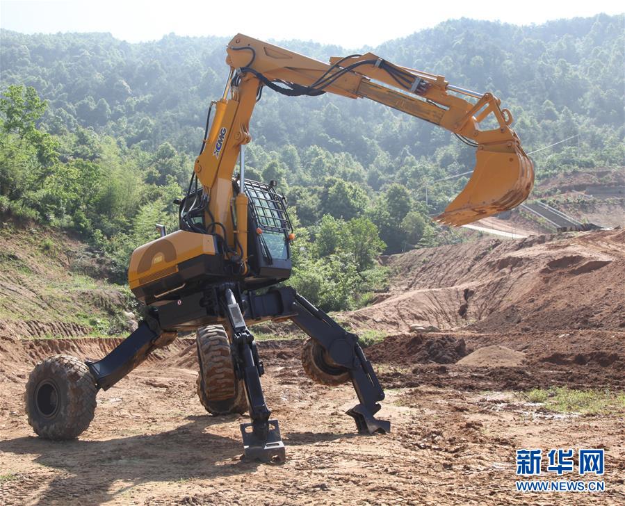
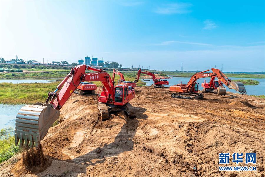
这台步履式挖掘机适用于复杂地形爆破钻孔、岩石破碎、重物搬运、吊装等作业(2016年5月25日摄)。新华社发(中国安能建设集团 供图)
抢险:“智能+”手段加速决口封堵
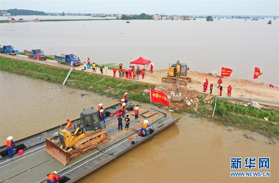
7月13日23时8分,随着操作手张剑文驾驶推土机将最后一车土石倒入决口处,江西省鄱阳县问桂道圩决口封堵现场汽笛长鸣、红旗猎猎。在抢险人员连续奋战83个小时后,127米宽的决口成功合龙。
7月3日以来,鄱阳县出现持续强降雨,昌江流域水位迅速上涨,多个站点连续超警戒。8日20时35分,鄱阳县鄱阳镇问桂道圩堤发生漫决,堤内1.5万亩耕地和6个村庄被淹,近万名群众被紧急转移。
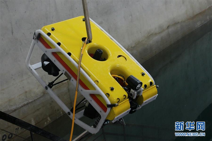
这台水下机器人可在决口封堵中,为研判水情提供可靠数据(2016年4月6日摄)。新华社发(中国安能建设集团 供图)
险情就是命令。中国安能建设集团第二工程局迅速调集400余名抢险人员、52台(套)装备星夜驰援,加上陆续赶来增援的火箭军、武警和预备役部队,一场防汛抢险阻击战就此打响。到达现场后,他们首先对现场情况进行勘查,包括测量决口宽度、水位和流速、地形等,了解施工场地和交通情况,进而设计封堵决口的抢险方案。
为尽快拿出抢险方案,在现场测量中,他们使用了三维激光扫描仪等仪器。“机器测量的效率是人力的数十倍甚至更多,同时测量的精准度更高。”中国安能建设集团第二工程局副总经理谌少英说。
在封堵决口的83个小时里,各种抢险利器轮番登场。
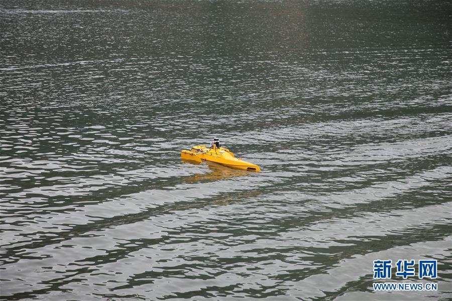
这台水上无人船可用于抢险中的水情侦测(2016年5月25日摄)。新华社发(中国安能建设集团 供图)
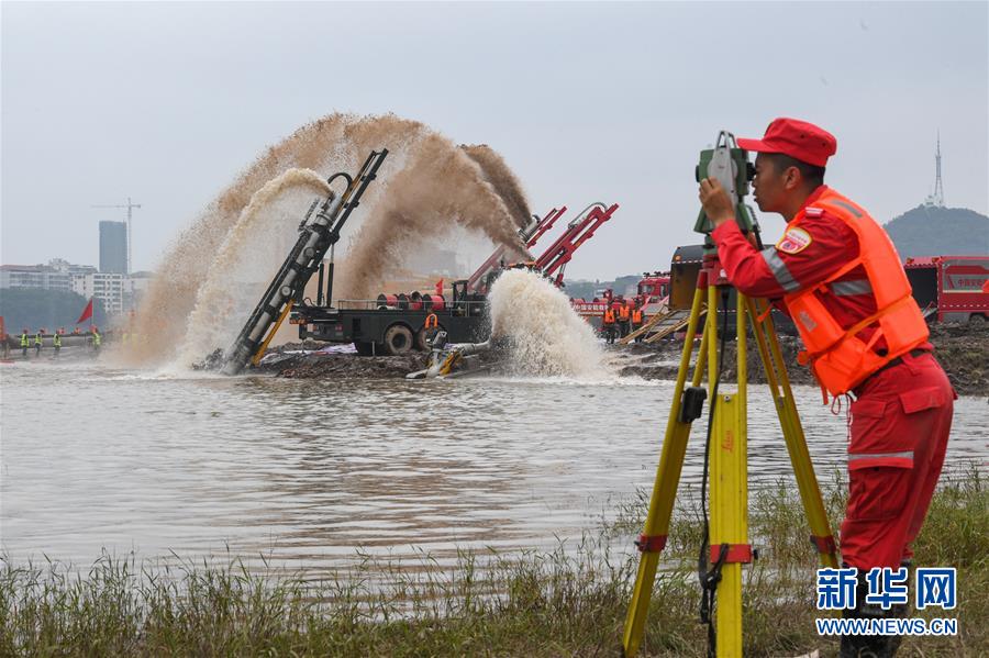
在封堵作业中,洪水流速是重要指标。如果水流速度过快,就会冲走抛投物。为了更好地掌握施工现场情况,及时调整物料和抛投速度,抢险人员使用自动水位计、雷达流速仪、无人机等设备对水流速度进行实时监测。
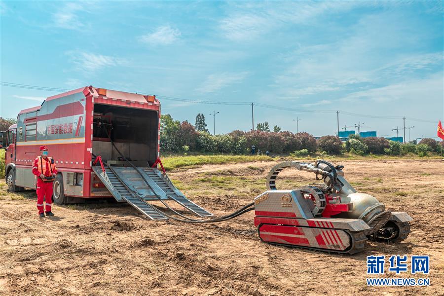
决口封堵现场,运送物料的大型车辆来回穿梭。抢险人员采取“堤头裹头保护、石碴戗堤进占、水上分层碾压、黏土抛填闭气”的机械化单向立堵战法,进行封堵作业。无人机、“龙吸水”、动力舟桥……一批抗洪抢险利器被投入“战场”,有了它们,再艰险的战役,也难不倒勇士。
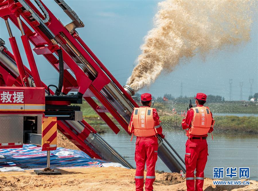
工作人员操作垂直式供排水抢险车(2020年5月31日摄)。新华社发(中国安能建设集团 供图)
水位、雨势、汛情……打开江西九江共青城市山塘水库水雨情基础信息库,21个山塘水库及重点圩堤的实时数据一目了然。
“以前巡堤,要靠人到现场看,再通过口述、笔记记录反馈巡查情况,汛情研判效率较低。”共青城市农业农村水利局标准化项目部经理王嘉龙说,如今系统自动记录管辖段水情变化,实时显示堤防沿线视频监控画面,一旦发现异常,管理员即将画面配以文字描述及时上传,研判效率大幅提高。
各式各样的“智能+”抗洪手段,正广泛运用到抗洪抢险中,为高效调度处置提供科学依据。6月30日,水利部水文水资源监测预报中心副主任刘志雨在水利部举办的新闻通气会上表示,如今,水利部收齐全国12万个报汛站的水雨情信息仅需10到15分钟,一次洪水作业预报的时间也仅需几十分钟。
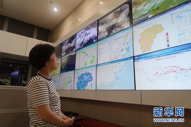
记者在江西省气象局气象信息监测平台看到,动态变化的卫星云图实时显示在大屏幕上,江西全境数千个地面气象站的数据逐分钟级汇总到这里。
这是子母式排水抢险车。在急需抽排积水的狭小空间,小巧的“子车”可在积水中顺畅前行,可360度旋转,涉水深度超过2米(2020年5月31日摄)。新华社发(中国安能建设集团 供图)
结合雷达、卫星、地面气象站等多方数据,通过人机交互得出的预警信息通过“平安江西”综治平台、大喇叭、抖音等各类传播媒介,第一时间被发布出去。
江西省气象台首席预报员许爱华介绍,7月6日至10日连续区域性暴雨期间,他们向受影响的6个设区市全网2113万用户发布强降雨预报信息,向6县全网195万用户发布暴雨红色预警信号,为组织群众提前转移提供精确参考。
堤坝安全是防汛抗洪的重点之一,及时探测险情,才能防患于未然。
江西鄱阳县昌洲乡中洲圩决口封堵中,中国安能建设集团抢险队员利用动力舟桥运送抢险装备(2020年7月13日摄)。新华社发(中国安能建设集团 供图)
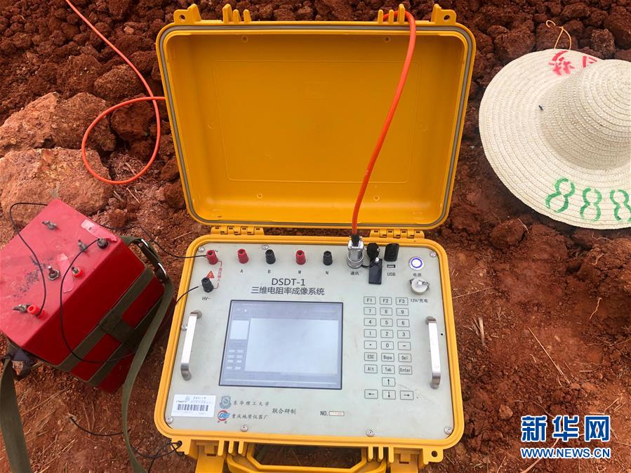
拿出一卷卷黄色电缆,将上面串着的上百个金属电极打入堤坝土体内,再将电缆接头与三台黄匣子连接,就能给堤坝做“CT”检查……今年汛期以来,东华理工大学的师生们也忙碌在抗洪抢险一线。
“这一技术的原理是通过DSDT-1型双分布式三维电阻率成像系统‘透视’坝体结构,快速判断堤坝是否存在空洞、裂缝、土层结合松散、管涌、渗流等隐患,有效做到提前防范、提前预警。”团队成员陈辉介绍,“防汛抗洪一线的数字化应用越来越普遍,智能防汛正逐渐成为主流。”
江西省气象台首席预报员在江西省气象局气象信息监测平台查看实时数据(2020年7月16日摄)。新华社发(中国安能建设集团 供图)
搜救:红外无人机“精准制导”寻人
7月9日下午5时许,吉安市峡江县消防救援大队接到求救电话,6人被洪水围困。雨势越来越大,水位不断上升,被困人员所处的建筑已成“孤岛”,随时有被冲毁的危险。
12小时,人机合力,一场“孤岛”救援惊险上演。
这是可在防汛抗洪中使用的无人机(资料照片)。新华社发(中国安能建设集团 供图)
情况紧急,当地先后派出两支救援队前往救援。但由于洪水已漫过路面,晚间视线受阻,救援队迟迟无法抵达,时间一分一秒过去,指挥部渐渐与被困人员失去了联系,情况越来越危险。
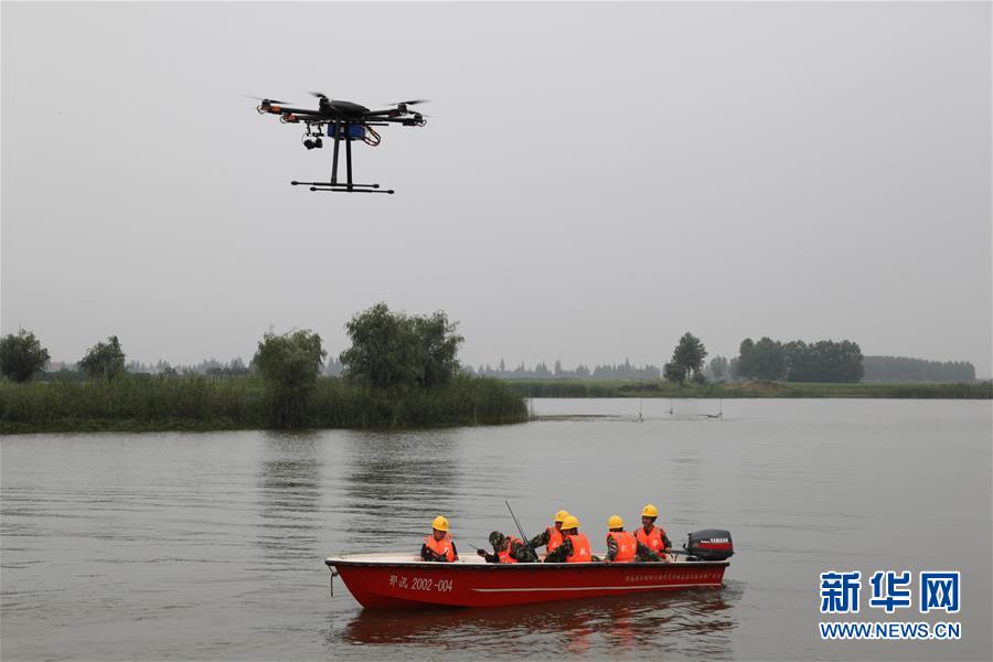
关键时刻,红外线无人机成为搜救“强兵”,深入“孤岛”探测被困人员情况,同时提供路面水情信息,为救援队提供合理的前进路线。
这是中国安能建设集团用于抢险的挖掘机(2020年5月31日摄)。新华社发(中国安能建设集团 供图)
凌晨4时,经无人机确认,受困人员全部安全。当地救援人员在红外线无人机遥控指引下,紧急制定救援方案和前进路线。10日凌晨5时36分,6名受困人员被成功解救。
此次防汛抗洪过程中,搭载了可见光、红外双波段视频相机、大视场测绘相机、光学相机等不同传感器的无人机,盘旋在鄱阳湖区上空,为灾情研判、蓄滞洪区运用论证提供科学支撑。
中国安能建设集团工作人员使用全站型电子测距仪测量水位水情(2020年6月12日摄)。新华社发(中国安能建设集团 供图)
“现在,湖区无论是堤防还是抗洪抢险设施设备都有了大幅提升。我们将把人民群众生命安全放在第一位,全力迎战大洪水。”江西省防汛抗旱指挥部秘书长徐卫明说,高科技手段赋能防汛抗洪,为救援抢险提供更有力的保障,但要打赢这场“战役”,仍需每个人都坚守岗位,众志成城。
这是三位电阻率成像系统(2020年7月16日摄)。该设备可以应用于探测堤坝险情,“透视”坝体结构,快速判断堤坝是否存在空洞、裂缝、管涌等隐患。 新华社发(中国安能建设集团 供图)
图集
【纠错】 责任编辑: 王萌萌
Anti-flood weapon helps the front line of flood fighting
2020-07-17 19:22:49 Source: Xinhuanet
Follow Xinhua
WeChat
Weibo
Qzone
Xinhua News Agency, Nanchang, July 17th, title: Flood fighting weapons help the front line of flood fighting
Xinhua News Agency reporters Wu Zhonghao, Cheng Di, Sun Nan
Since June, there has been continuous heavy rainfall in southern my country, with large accumulated rainfall and wide coverage, and river water levels in the middle and lower reaches of the Yangtze River have skyrocketed. At 0:00 on July 12, my country's largest freshwater lake Poyang Lake Xingzi Station broke the highest water level in history in 1998. As of 8 o'clock on the 17th, the water level of Poyang Lake's iconic hydrological station was 21.97 meters, still exceeding the warning line by 2.97 meters, and the flood control situation in the Poyang Lake Basin was still grim.
Radar flow meter, big data early warning, infrared drone search and rescue trapped people... In the face of fierce floods, high technology is redefining the "tactics" of flood control in the new era. More and more powerful anti-flood technologies are used in the front line of flood fighting and rescue, making rescue and rescue more scientific and efficient.
(Xinhua All-Media Headline·Interaction of Graphic and Text) (1) Flood fighting weapon helps the front line of flood fighting
This walking excavator is suitable for blasting drilling, rock crushing, heavy material handling, lifting and other operations in complex terrain (photographed on May 25, 2016). Published by Xinhua News Agency (Photo courtesy of China Aneng Construction Group)
Emergency rescue: "Smart+" means speed up the breach and block
At 23:8 on July 13th, as operator Zhang Jianwen drove the bulldozer to dump the last vehicle into the crest, Wengui Daowei, Poyang County, Jiangxi Province blocked the whistle and red flag hunting at the scene. After 83 hours of continuous fighting by the rescue personnel, the 127-meter wide break succeeded.
Since July 3, Poyang County has experienced continuous heavy rainfall, the water level of the Changjiang River Valley has risen rapidly, and multiple stations have continuously exceeded the alert. At 20:35 on the 8th, the Embankment of Wengui Daowei, Poyang Town, Poyang County, broke out. The 15,000 mu of cultivated land and 6 villages in the embankment were flooded, and nearly 10,000 people were urgently transferred.
(Xinhua all-media headline·Interaction with pictures and texts) (2) Anti-flood weapons help the front line of flood fighting
This underwater robot can provide reliable data for the study and judgment of water regimes during the breach and blockage (photographed on April 6, 2016). Published by Xinhua News Agency (Photo courtesy of China Aneng Construction Group)
Dangerous circumstances are orders. The Second Engineering Bureau of China Aneng Construction Group quickly mobilized more than 400 rescue personnel, 52 units (sets) of equipment to rush to the starry night, and the rocket army, armed police and reserve forces that came to reinforcements one after another, a flood prevention battle started. After arriving at the site, they first surveyed the site, including measuring the width of the breach, water level and velocity, topography, etc., to understand the construction site and traffic conditions, and then design a rescue plan to block the breach.
In order to come up with a rescue plan as soon as possible, they used three-dimensional laser scanners and other instruments in the field measurement. "The efficiency of machine measurement is dozens or more times that of manpower, and the accuracy of measurement is higher." said Chen Shaoying, deputy general manager of the Second Engineering Bureau of China Anneng Construction Group.
In the 83 hours of blocking the break, various rescue tools appeared in turn.
(Xinhua All Media Headline·Graphic Interaction) (3) Anti-Flood Weapon Helps Frontline Anti-Flood
This unmanned watercraft can be used for water regime detection in rescue operations (photographed on May 25, 2016). Published by Xinhua News Agency (Photo courtesy of China Aneng Construction Group)
In the plugging operation, the flood velocity is an important indicator. If the water flow is too fast, the projectile will be washed away. In order to better grasp the conditions of the construction site and adjust the material and throwing speed in time, rescuers use automatic water level gauges, radar flow meters, drones and other equipment to monitor the water flow speed in real time.
The site was blocked by a breach, and large vehicles transporting materials shuttled back and forth. Rescue personnel adopted the mechanized one-way stand-up blockage method of "head-wrapped dyke head protection, rock ballast dyke occupation, layered rolling on water, and clay dumping and air-locking" to carry out blocking operations. Unmanned aerial vehicles, "dragons absorb water", powered boat bridges...a batch of flood fighting and rescue tools have been put into the "battlefield". With them, no matter how difficult the battle is, the warriors will not fail.
(Xinhua All Media Headline·Graphic Interaction) (4) Anti-Flood Weapon Helps Frontline Anti-Flood
The staff operates a vertical water supply and drainage emergency vehicle (photographed on May 31, 2020). Published by Xinhua News Agency (Photo courtesy of China Aneng Construction Group)
Early warning: digital platform enables flood situation judgment
Water level, rain potential, flood situation... Open the basic information database of water and rain in Shantang Reservoir of Gongqing City, Jiujiang, Jiangxi, and real-time data of 21 Shantang Reservoir and key dikes can be seen at a glance.
“In the past, when patrolling the dike, it was necessary to rely on people to see the site, and then record the inspection through oral and notes. The efficiency of flood research and judgment was low.” said Wang Jialong, manager of the standardization project department of the Gongqing Urban Agriculture and Rural Water Resources Bureau. Now the system automatically records the water in the jurisdiction. The situation changes, real-time display of the video monitoring screen along the dike, once an abnormality is found, the administrator uploads the screen with a text description in time, and the efficiency of research and judgment is greatly improved.
Various "smart +" flood fighting methods are being widely used in flood fighting and rescue, providing a scientific basis for efficient dispatch and disposal. On June 30, Liu Zhiyu, deputy director of the Hydrology and Water Resources Monitoring and Forecasting Center of the Ministry of Water Resources, said at a news conference held by the Ministry of Water Resources that today, the Ministry of Water Resources only collects the water and rain information of 120,000 flood stations in the country in 10 to 15 minutes. , The time for a flood operation forecast is only tens of minutes.
The reporter saw on the meteorological information monitoring platform of the Jiangxi Meteorological Bureau that the dynamically changing satellite cloud image was displayed on the big screen in real time, and the data of thousands of ground weather stations throughout Jiangxi was summarized here every minute.
(Xinhua All Media Headline·Graphic Interaction) (5) Flood control weapon helps the front line of flood control
This is a child-mother type drainage rescue vehicle. In a small space where there is an urgent need to drain the accumulated water, the small "sub-car" can move smoothly in the accumulated water, can rotate 360 degrees, and the wading depth exceeds 2 meters (photographed on May 31, 2020). Published by Xinhua News Agency (Photo courtesy of China Aneng Construction Group)
Combining radar, satellite, ground weather station and other multi-party data, the early warning information obtained through human-computer interaction is released through the “Ping An Jiangxi” comprehensive management platform, large speakers, vibrato, and other communication media.
Xu Aihua, chief forecaster of Jiangxi Provincial Meteorological Observatory, introduced that during the continuous regional rainstorm from July 6 to 10, they issued strong rainfall forecast information to 21.13 million users in the entire network of the six districts and cities affected, and 1.95 million in the 6 counties. The user issued a red rainstorm warning signal to provide an accurate reference for organizing the masses to move ahead.
The safety of dykes and dams is one of the key points of flood control and flood control, and timely detection of dangers can prevent accidents before they happen.
(Xinhua All-Media Headline·Interaction with Pictures and Texts) (6) Flood Fighting Weapons Help Frontline Flood Fighting
During the closure of Zhongzhouwei, Changzhou Township, Poyang County, Jiangxi Province, rescue team members of China Aneng Construction Group used power pontoon bridges to transport rescue equipment (photographed on July 13, 2020). Xinhua News Agency (Photo courtesy of China Anneng Construction Group)
Take out a roll of yellow cable, drive hundreds of metal electrodes strung on it into the soil of the dam, and then connect the cable connector to three yellow boxes, you can do a "CT" inspection of the dam...Since the flood season this year, Teachers and students of East China University of Technology are also busy fighting floods.
"The principle of this technology is to use the DSDT-1 dual distributed three-dimensional resistivity imaging system to'see through' the dam structure to quickly determine whether there are hidden dangers such as cavities, cracks, loose soil layers, piping, seepage, etc. "Prevent in advance and pre-warn in advance." Chen Hui, a team member, said, "The digital application of flood control and flood control is becoming more and more common, and intelligent flood control is gradually becoming mainstream.
(Xinhua All Media Headline·Graphic Interaction) (7) Anti-flood weapon helps the front line of anti-flood
The chief forecaster of Jiangxi Meteorological Observatory checks real-time data on the Meteorological Information Monitoring Platform of Jiangxi Meteorological Bureau (photographed on July 16, 2020). Published by Xinhua News Agency (Photo courtesy of China Aneng Construction Group)
Search and rescue: infrared drone "precise guidance" to find people
At about 5 pm on July 9, the fire rescue brigade of Xiajiang County, Ji'an City received a call for help, and 6 people were besieged by the flood. The rain is getting heavier and the water level is rising, and the building where the trapped people are located has become an "island", which is in danger of being washed away at any time.
12 hours, human and machine work together, an "island" rescue thrill was staged.
(Xinhua All-Media Headline·Interaction with Pictures and Texts) (8) Anti-flood weapons help the front line of flood fighting
This is an unmanned aerial vehicle that can be used in flood control (data photo). Published by Xinhua News Agency (Photo courtesy of China Aneng Construction Group)
The situation was urgent, and two rescue teams were sent to the local area. However, due to the flood flooding over the road and the obstruction of sight at night, the rescue team was unable to arrive. The time passed, and the headquarters gradually lost contact with the trapped personnel, making the situation more and more dangerous.
At a critical moment, infrared drones have become search and rescue "strong soldiers", go deep into "isolated islands" to detect the situation of trapped people, and at the same time provide information on pavement water conditions to provide a reasonable route for rescue teams.
(Xinhua All Media Headline·Graphic Interaction) (9) Anti-flood weapon helps the front line of anti-flood
This is an excavator used by China Anneng Construction Group for emergency rescue (photographed on May 31, 2020). Published by Xinhua News Agency (Photo courtesy of China Aneng Construction Group)
At 4 o'clock in the morning, the drone confirmed that all trapped persons are safe. Under the guidance of infrared drone remote control, local rescuers urgently formulated rescue plans and advance routes. At 5:36 on the 10th, 6 trapped people were successfully rescued.
In the process of flood prevention and flood control, drones equipped with different sensors such as visible light, infrared dual-band video cameras, large field of view mapping cameras, optical cameras, etc., hovered over the Poyang Lake area to provide science for disaster research and judgment and demonstration of flood storage and detention areas. support.
(Xinhua All Media Headlines·Graphic and Textual Interaction) (10) Anti-Flood Weapon Helps Frontline Anti-Flood
The staff of China Aneng Construction Group used a total-station electronic rangefinder to measure the water level and water regime (taken on June 12, 2020). Xinhua News Agency (Photo courtesy of China Anneng Construction Group)
"Now, both dikes and flood fighting facilities and equipment in the lake area have been greatly improved. We will put the people's life safety first and try our best to face the flood." said Xu Weiming, secretary general of Jiangxi Provincial Flood Control and Drought Relief Headquarters, Gao Scientific and technological means can empower flood prevention and fight floods, and provide more powerful guarantees for rescue and rescue. However, to win this "battle", everyone still needs to stick to their posts and unite.
(Xinhua All Media Headlines·Graphic and Textual Interaction) (11) Anti-flood weapon helps the front line of anti-flood
This is a three-digit resistivity imaging system (photographed on July 16, 2020). The device can be used to detect the danger of dams, "see through" the dam structure, and quickly determine whether there are hidden dangers such as cavities, cracks, and piping in the dam. Published by Xinhua News Agency (Photo courtesy of China Aneng Construction Group)
Atlas
[Correction] Editor in charge: Wang Mengmeng


