As if one catastrophe is not enough.
Watch where that chinese aircraft carrier is. It will attack Philippines the moment their typhoon leaves.
Typhoon Vongfong rapidly intensifies as it nears the Philippines
By Taylor Ward, CNN Meteorologist
Updated 1403 GMT (2203 HKT) May
Typhoon Vongfong makes landfall and will continue to lash the Philippines 01:49
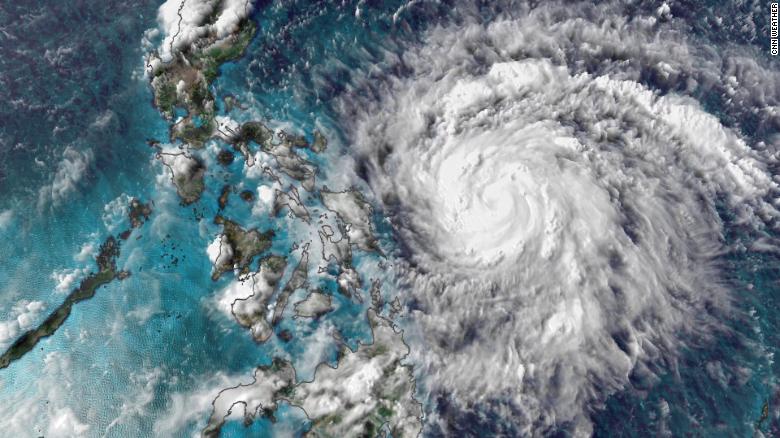
(CNN)Typhoon Vongfong is rapidly intensifying -- and the Philippines is in its path.
With typhoons or hurricanes, rapid intensification is an increase in maximum sustained winds of 35 mph (55 kph) in 24 hours.
From Tuesday afternoon to Wednesday afternoon, Vongfong -- known as Ambo in the Philippines -- easily met that definition, strengthening from a modest tropical storm with winds of 60 mph (95 kph) to the equivalent of a major hurricane. Maximum sustained winds are now up to 120 mph (195 kph) and the storm is still strengthening.

This area of the world is no stranger to rapid intensification. Many storms undergo rapid intensification each year due to the extremely warm sea surface temperatures.
But this is the first named storm of the season in the West Pacific.
It didn't exist until Tuesday, and now it will hammer the Philippines as the equivalent of a category 3 or 4 storm on the Saffir-Simpson scale.
Vongfong's impact
Weather models had difficulty forecasting the intensity of Vongfong, in part because of the small size of the storm.
Now that the storm has intensified so quickly there is no doubt that it will be more than a rainmaker when it reaches the coast.
"Very heavy rainfall, damaging winds, and powerful storm surge are all major concerns with this storm," CNN Meteorologist Tom Sater said.
Watch where that chinese aircraft carrier is. It will attack Philippines the moment their typhoon leaves.
Typhoon Vongfong rapidly intensifies as it nears the Philippines
By Taylor Ward, CNN Meteorologist
Updated 1403 GMT (2203 HKT) May
Typhoon Vongfong makes landfall and will continue to lash the Philippines 01:49
(CNN)Typhoon Vongfong is rapidly intensifying -- and the Philippines is in its path.
With typhoons or hurricanes, rapid intensification is an increase in maximum sustained winds of 35 mph (55 kph) in 24 hours.
From Tuesday afternoon to Wednesday afternoon, Vongfong -- known as Ambo in the Philippines -- easily met that definition, strengthening from a modest tropical storm with winds of 60 mph (95 kph) to the equivalent of a major hurricane. Maximum sustained winds are now up to 120 mph (195 kph) and the storm is still strengthening.

This area of the world is no stranger to rapid intensification. Many storms undergo rapid intensification each year due to the extremely warm sea surface temperatures.
But this is the first named storm of the season in the West Pacific.
It didn't exist until Tuesday, and now it will hammer the Philippines as the equivalent of a category 3 or 4 storm on the Saffir-Simpson scale.
Vongfong's impact
Weather models had difficulty forecasting the intensity of Vongfong, in part because of the small size of the storm.
Now that the storm has intensified so quickly there is no doubt that it will be more than a rainmaker when it reaches the coast.
"Very heavy rainfall, damaging winds, and powerful storm surge are all major concerns with this storm," CNN Meteorologist Tom Sater said.
